API field
Horizon profile
The skyline of distant hills and buildings, as azimuth and elevation pairs
Unit ° azimuth / ° elevation
What it is
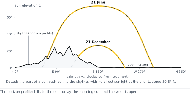
The horizon profile describes the skyline around the site: for a list of compass bearings, the height of the skyline above the horizontal in degrees. The model uses it to remove the direct sunlight when the sun is behind the skyline and to reduce the diffuse light from the parts of the sky the skyline hides. An empty profile means a flat horizon.
Typical values and how to get it
Generate it from the location, which fetches the profile from PVGIS terrain data at 48 bearings. A survey with a clinometer gives a nearer skyline more accurately. Bearings count clockwise from north; the elevation list must be as long as the bearing list.
References
- European Commission Joint Research Centre, PVGIS user manual — horizon profile (re.jrc.ec.europa.eu/pvg_tools)
API
site.horizon